Research
The CAI undertakes and supports a variety of archaeological research projects involving field and laboratory work in the American Midwest. Our researchers are skilled in state-of-the-art archaeometric, remote sensing, and spatial analysis techniques in addition to analytical specialties that include historic materials, ceramics, fauna, and human osteology.
Recent FieldworkLab and Archival ProjectsArchaeology Field SchoolRecent Fieldwork
Fort Kaskaskia
Miller Grove
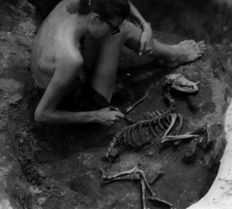
The Miller Grove site is a freed slave African-American community established in Pope County in 1844. Contained entirely on the Shawnee National Forest, the remains of this settlement (1844-1920's) include over 20 homesteads, a cemetary, a church/school, and lanscape features. Oral histories collected from descendants reveal that community members were actively involved in the Underground Railroad helping runaways from the slave states pass safely through Southern Illinois on their path to freedom. Archaeological investigations conducted by the Shawnee national Forest and the SIU archaeological field school at "Abby's Place", the home site of Abby and Bedford Miller in the mid to late 1800s, have recovered information about the personal belongings, tools, foodways, and daily life of the members of this now-vanished community. The Millers and other members of the community lived in log houses on farms that also contained smokehouses, barns, cisterns, outbuildings and other structures necessary for farm life in the mid-1800s.
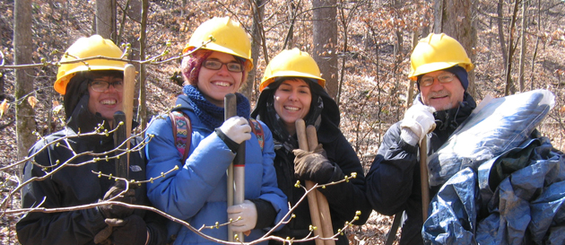
SIU field schools participated in excavations at Miller Grove in 2017 and 2018 in partnership with the Shawnee National Forest.
PXRF Rock Art Study
In 2013, the CAI was awarded a grant from the National Geographic Society (NGS) to conduct a portable X-ray fluorescence (PXRF) analysis of the pigments in up to 10 Native American pictograph sites in southern Illinois. The sample sites contained pictographs believed to date to the Mississippian (N = 8) and historic or post-1673 (N = 2) periods. Working in cooperation with Dr. Jan Simek of the University of Tennessee–Knoxville, CAI staff collected data from a number of pictographs at four of the sites in spring 2013. We plan to visit the remainder of the sites in February 2014 and submit the results of the analyses to the National Geographic Society by summer 2014. We also will present a paper giving the results of the PXRF analysis at the Society of American Archaeology (SAA) meetings in Austin, Texas, in April 2014.
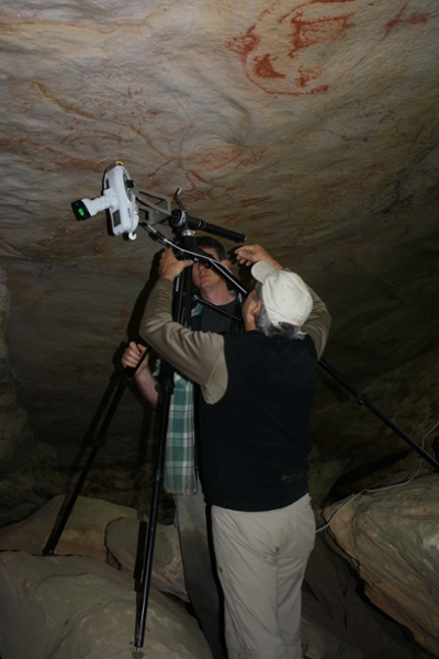 Dr. Jan Simek (white hat) and Doug Kosik (CAI) conducting PXRF analysis of possible historic period paintings at the Parsons site in southern Illinois.
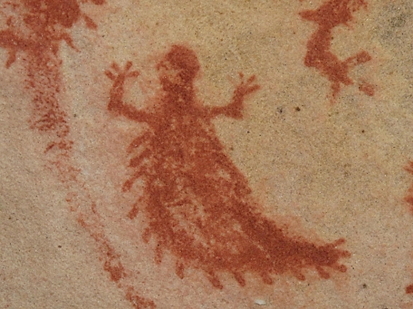 Parsons site pictograph
Kincaid Mounds Research
Since 2003, SIUC archaeologists Brian Butler (CAI) and Paul Welch (Dept. of Anthropology) have been engaged in a long-term program of research at this poorly known Mississippian mound center. Located in the Black Bottom of the Ohio River near Paducah, Kentucky, this 150-plus acre complex straddles the Massac-Pope County line. The Kincaid site was first investigated by University of Chicago archaeologists under the direction of Faye-Cooper Cole from 1934 to 1944, resulting in the well-known 1951 volume Kincaid, a Prehistoric Illinois Metropolis.
The initial goals were to assess the organization and complexity of the site and chronicle its emergence and demise as a major mound center, none of which were adequately documented by the previous work. The plan was to employ large-scale remote sensing and pursue specific questions that could be addressed by small, targeted excavations. The primary vehicle of the fieldwork was to be the annual archaeological field school, jointly supported by the Department and the Center.
A key aspect of the work has been a large-scale geophysical survey of the Massac County portions of the site, completed in early 2009. The survey has primarily used magnetometry. This work has been accomplished principally by R. Berle Clay (Cultural Resource Analysts, Lexington, Ky), Michael L. Hargrave (US Army COE), and Staffan Peterson (Glenn Black Laboratory of Archaeology at Indiana University, now Indiana Department of Natural Resources). Additional survey contributions have been made by John E. and John A. Schwegman of Metropolis, Illinois.
The results of the geophysical survey, along with the results of excavations targeted on the basis of the survey results, have been eye-opening, revealing that the site is much larger and more complex than originally thought. The new work has brought the realization that there are many more mounds at the site than previously believed (most of them small) and that habitation areas are much more extensive than surface artifact distributions had suggested. Below is a brief listing of the fieldwork to date:
2003 Small-scale testing was done at the southeast corner of the main plaza to determine feasibility of locating an observation platform and parking area there. Work confirmed the presence of the remnants of a small mound (Mxo2) and encountered a heavily used Baumer (Early/Middle Woodland) occupation surface (Butler and Welch 2006).
2005 Excavations in the southwestern corner of state property confirmed the presence of a low platform mound (called the West Mound) and adjacent habitation areas, well outside the previously suspected western boundary of the site. The habitation surface, which contains numerous structures, was hidden under 40 cm of alluvium.
2006 Known and suspected palisade lines on both the northern and western edges of the site were explored. Work confirmed the existence of a north-south palisade on the west side, previously indicated in aerial photographs and geophysical survey. A separate excavation was done by CAI in a 11 x 11 m block for the observation platform adjacent to the lakefront road west of the 2003 work. Some remnant Mississippian features were found, but mostly large refuse-filled Baumer pits (Early and Middle Woodland) were excavated.
2007 Excavations took place on the top of the large mound, Mxo8, confirming the existence of a 22 m diameter circular wall trench structure at or just below the present surface. The structure had been identified in geophysical survey of the mound top by John E. Schwegman. A large central posthole was also discovered. Evidence suggests the structure had several building phases and was probably roofed.
2008 Work took place in the northwestern part of the state land confirming the existence of a previously unsuspected east-west palisade line, identified in a 2008 geophysical survey. A possible mound remnant was tested but proved not to be a mound. A house complex in the same area was also investigated. Confirmation of this “new” palisade line was an important development, extending the western edge of the site much farther to the west and adding at least 13 ha to the defined site area. This palisade would have enclosed the West Mound complex within the fortified area.
2009 Two excavation areas were opened as part of the dissertation research of Tamira Brennan. These targeted magnetic anomalies in the geophysical survey thought to be structures: one along the eastern edge of the plaza and a second adjacent to the west side of the Mound 8 in an area now identified as Mxv1E. The plaza units uncovered a burned house with whole vessels and other usable artificats on the floor, indicating that the fire was not intentional. Mxv1E proved to be a palimpsest of features, some of which were not visible in the geophysical survey.
2010 Three excavation blocks were opened just inside of the site's northern paliside line as a continuing aspect of Brennan's dissertation research, revealing several structures, a handful of other features, and the first late Lewis phase (Late Woodland) pit documented in SIUC investigations. Additional work was completed on Douglas Mound to map the footings of a historic barn that was built and torn down in the 20th century.
2011 Two excavations were conducted simultaneously. The first tested unusual magnetic signatures in Kincaid's western field, in an area designated Mxv1F. These were revealed to be an extensive stratified Archaic deposit. Nine projectile points in good stratigraphic order indicate a span from the late Middle Archaic to the Early Woodland. The second explored a portion of the lower southern flank of Mxo8 near the east edge, using a series of soil probes followed by four 2 x 2 meter units. South of Mxo8 a pre-mound sand-over-clay prepared surface or structure floor was uncovered with a complex of associated postholes, likely tied to Early Kincaid occupation. Slopewash and a small part of the outer edge of the Mxo8 mound thickly covered the pre-mound surface, and beneath the surface Lewis-era Late Woodland ceramics appeared.
Crawford Farm Site
The CAI, as part of a contract with the Illinois State Archaeological Survey (ISAS), is also completing the artifact analyses and report of investigations for the historic period Crawford Farm site (11Ri-81). Located in the Rock River valley of northwestern Illinois, the Crawford Farm site originally was excavated by Elaine Bluhm and Dr. John McGregor of the University of Illinois in the late 1950s and early 1960s.

Image at left: The Sauk leader Blackhawk, who is believed to have lived at the Crawford Farm site when he was a boy and a young man.
This work revealed that the site primarily consisted of the remains of a major late eighteenth- to early nineteenth-century Sauk village (Saukenauk) possibly associated with the famous Sauk leader Blackhawk.
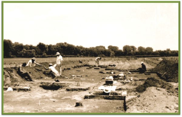
Image at left: 1950s–1960s University of Illinois excavations at the Crawford Farm site.
The U of I excavations encountered hundreds of pit features and ten structures associated with the Sauk and earlier occupations. A report of investigations, however, was never completed for the site.
 The artifacts, excavation forms, maps, and other records associated with the U of I excavations are currently on loan to the CAI for use in completion of the Crawford Farm site report. The CAI staff have completed the artifact analyses, with the entire report, which will be made available to other researchers and the general public as part of the ISAS publication series, anticipated in 2014.
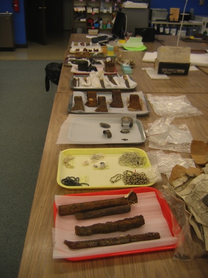
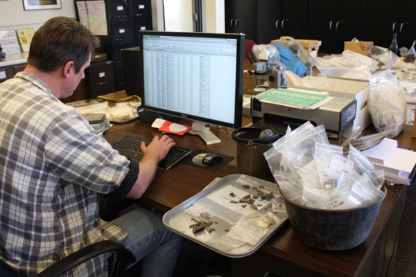
Image at left: Crawford Farm site artifacts at the CAI curation facility.. Imaget at right: Doug Kosik (CAI) analyzing Crawford Farm brass/copper kettle remains.
Bridges Site Investigation
In August 2013, the CAI conducted investigations for IHPA at the Bridges Tavern site in Johnson County, which is located directly on the Trail of Tears. The site currently consists of the archaeological remains of the Bridges family tavern and a one-room log structure called the “Wayside Store.” Oral histories (ca. 1818–1940) collected in the 1930s stated that Cherokee traveling along the “Trail of Tears” purchased alcohol and other supplies at the Wayside Store while journeying through southern Illinois in 1837–1839. The goal of the investigations was to determine if the structure indeed could date to that period. Archival research revealed that the Bridges family indeed were selling alcohol and operating a store at the site as early as the 1840s, supporting the oral history. Architectural analysis of the Wayside Store also revealed that it was a pre-1800 structure that potentially could date to the 1830s.
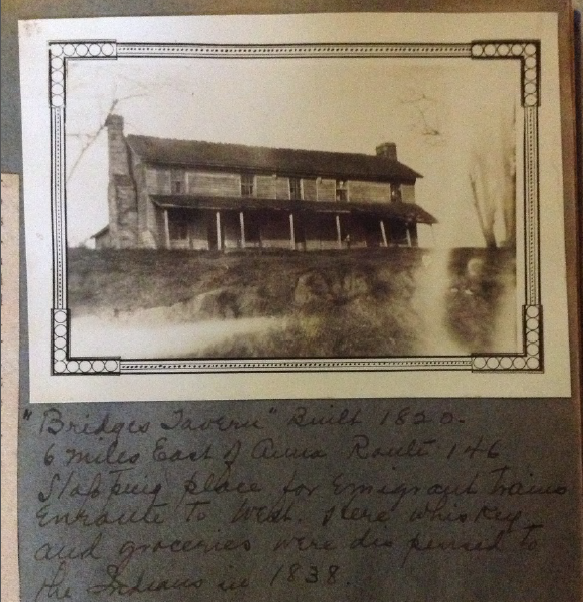 Image at left: Bridges Tavern, ca. 1934
Archaeological investigations around and within the structure recovered early nineteenth-century artifacts and indicated that it represented an outbuilding (such as a store) rather than a residence. Our conclusion is that the combined lines of evidence—oral history, archaeological, architectural, and archival—indicate a strong likelihood that the Wayside Store indeed does date to the Trail of Tears (1837–1839) period. As such, it represents one of the only structures still standing in southern Illinois associated with this event.
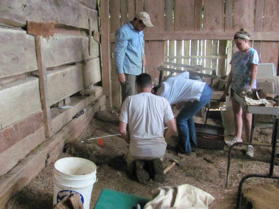
Image at left: Excavations adjacent to log “store” building (left) at the Bridges Tavern site.
Lab & Archival Research
Cherokee Trail of Tears
The Cherokee Trail of Tears (TOT) is associated with the forced removal of the Cherokee people of Tennessee, Georgia, North Carolina, and other parts of the Southeast to the western United States in the late 1830s. From 1837 to 1839, thousands of Cherokee traveled through southern Illinois on what was known as the Golconda-Cape Girardeau Trace (now Illinois Route 146). Traveling on foot, horseback, and in wagons, the Cherokee camped along this road, bought supplies from settlers and tavern keepers, and buried those who died along this route. In 2013, the CAI engaged in three separate Trail of Tears–related projects for three separate agencies—the National Park Service (NPS), the USDA Forest Service, and the Illinois Historic Preservation Agency (IHPA).
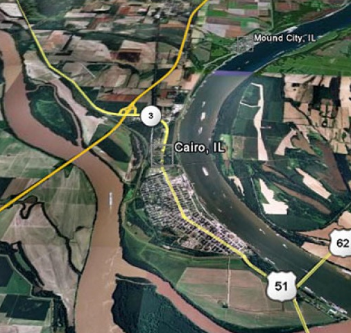
Location of Illinois Section of Trail of Tears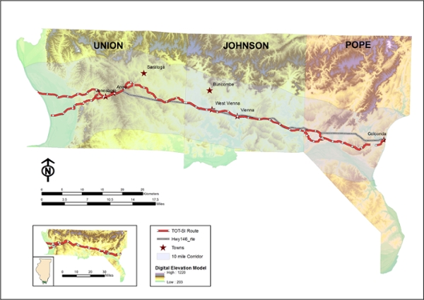
Image: Map of Trail of Tears across the United States
Information Sources:
- Illinois State Archives, Illinois Public Domain Land Tract Sales URL: www.ilsos.gov/isa/pubdomsrch.jsp
- 30-Meter Digital Elevation Model (DEM), Illinois. URL: clearinghouse.isgs.illinois.edu/data/elevation/surface-elevation-30-meter-digital-elevation-model-dem
- Illinois PLSS county, state and land section. URL: http://isgs.illinois.edu/plss
The project we conducted for the NPS in 2012–2013 consisted of an archival and historical study of the types and number of TOT-related sites in southern Illinois associated with the Cherokee Removal. Such properties included taverns, mills, residences, stores, ferries, cemeteries, and campgrounds. We examined the distribution of the above properties within a 10-mile wide corridor (five miles north and five miles south) of Route 146, the modern version of the trail that extended for 55 miles from Golconda on the Ohio River in the east to several ferry locations on the Mississippi River in the west. The results of this research were used to create a GIS database showing the distribution of cultural properties in both tables and figures (see below). A total of 545 cultural and 31 natural (springs) properties were located within the corridor. Of these, 414 were mappable as to location. Thirty-eight of these sites have associated oral history or written documents that link them to the Trail of Tears. Fifteen of these sites could be identified to specific location, while 23 could be located in only a general sense.
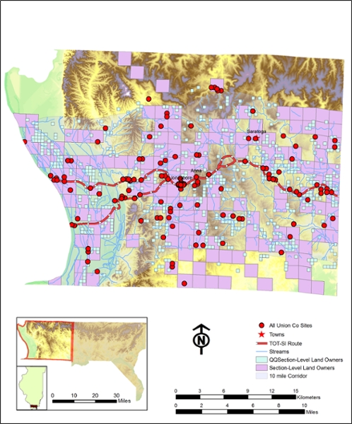
GIS map of 1830s property owners along the Trail of Tears in Union County, Illinois.
In the spring of 2013, the CAI assisted Shawnee National Forest archaeologists in the testing of two sites—11U316 and 11U615—located on Forest Service land along the southern branch of the trail that once led to a ferry used by the Cherokee to cross the Mississippi River and enter into Missouri. Indications that these sites potentially were associated with the Cherokee TOT included that one (11U316) possessed a spring, which could have supplied water to Cherokee emigrants, while the other (11U615) was known to have produced an early nineteenth-century smoking pipe manufactured by Moravian missionaries for trade to the Cherokee and other southeastern Native American peoples. The field crews for both sites consisted of volunteers enrolled in the Forest Service’s “Passport in Time” volunteer archaeology. Testing of site 11U615 recovered pre-1820 green shell edged creamware ceramic flatware sherds. This indicated that the spring at the site was in use in the early 1800s and potentially could have represented a stopping point for the Cherokee to obtain water for themselves and their animals. Archaeological testing of site 11U316 failed to recover additional early 1800s artifacts similar to the Moravian smoking pipe but did encounter the remains of a substantial prehistoric Mississippian period (AD 1000–1500) village that contained subsurface features.
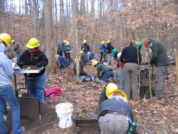
Passport in Time volunteers at site 11U615.
In August 2013, the CAI conducted investigations for IHPA at the Bridges Tavern site in Johnson County, which is located directly on the Trail of Tears.
Crawford Farm Lead
 Interdepartmental collaboration: The Crawford Farm site (11Ri81) represents the ca. 1780-1815 location of the historic Sac village of Saukenauk in northwestern Illinois.
 The University of Illinois field school recovered a large artifact collection from the site in the 1950s and early 1960s prior to its destruction by a highway construction project in 1963. Reanalysis of the Crawford Farm artifact collection in 2014-2015 by Southern Illinois University (SIU) archaeologists identified a perforated rectangular copper kettle scrap interpreted as representing a possible copper sieve for lead shot production.
To our knowledge, this artifact type has not been previously identified, leading us to use portable X-ray fluorescence (PXRF) and scanning electron microscopy (SEM) to confirm our observations. Interpretation is that melted lead in the kettle would drop through the holes into a bucket of water to form lead shot.
The results of this study, although limited, point out the usefulness of recent methodological advances such as PXRF in historic artifact analysis and identification.
Mastodons in Southern Illinois?
The answer is an emphatic first-time YES for Jackson County. In a collection recently donated to the Center for Archaeological Investigation, there was a most intriguing find, a partial mastodon tibia which is the first of its kind to be recovered in Jackson County, Illinois.
The bone was recovered from a rock shelter by amateur collectors over four decades ago. In the hands of CAI researchers under the direction of Dr. Mark Wagner, the mastodon bone is now undergoing state-of-the-art analysis to answer important questions about how and when, exactly, it came to be deposited in a rock shelter here in southern Illinois. Making use of the university’s new portable X-ray Florescence analyzer, CAI researchers recorded data to determine the origin of dark stains observed on the bone, finding that they consisted primarily of manganese.
This finding resolves one critical question: where did the stains come from? The pXRF data confirms that the stains resulted from the bone’s deposition in a watery environment, rather than the result of human activities such as burning. The bone has recently been delivered to the Illinois State Museum, where ISM paleontologists will determine whether or not enough collagen remains to conduct c14 dating.
The CAI received a grant from the Illinois Association for Advancement of Archaeology, a member of the Society for American Archaeology Council of Affiliated Societies whose mission is to unite all persons (amateurs, professionals, students and educators) interested in the archaeology of Illinois, to conduct radiocarbon analysis to determine the date of the mastodon bone and further our understanding of how and when the bone came to rest in the rock shelter.
Mound City Naval Base
Civil War Research: Mound City Naval Base – 2013
The CAI is currently creating a GIS database for the U.S. naval base (1862–1872) at Mound City, Illinois, on the Ohio River. Established in 1862, the naval base was the home of the U.S. Mississippi River Squadron.
Comprised of over 200 ironclads, timberclads, hospital ships, transports, and other vessels, Mississippi River Squadron, under the commands of Commodore Foote and Admiral David Dixon Porter, was instrumental in breaking the Confederate stranglehold on the Mississippi, Tennessee, and Cumberland Rivers.
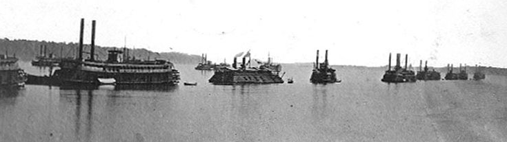
The Mississippi River Squadron off Mound City, with Admiral Porter’s flagship Blackhawk (far left) in the lead.
The boats of the Mississippi River Squadron fought in a number of the most famous engagements in the west, including the battles of Belmont, Ft. Donelson, Ft. Henry, Island No. 10, and Vicksburg.
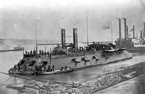
The ironclad USS Cairo, which was constructed at Mound City.
The naval base itself consisted of a shipyard or marine ways, foundry, marine barracks, supply offices, hospital, and other facilities. All of these structures, with the exception of the marine ways, have long since vanished. Using a series of Civil War and later maps, photographs, charts, and other documents, Ph.D. student Go Matsumoto (CAI, SIU Anthropology Department) has constructed a GIS database for Mound City that identifies the locations of the naval yard and other Civil War–era facilities as well as a now-vanished very large prehistoric mound that gave Mound City its name.
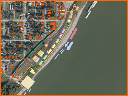
GIS overlay of Mound City showing locations of Civil War–era buildings (red),
naval yard facilities (light colored blocks on shore), and mooring stations
of Civil War vessels in the Ohio River (light colored blocks in water).
Through the construction of this database, we were able to identify several areas of the naval base that could potentially be investigated through archaeology. We also were able to identify the mooring station of Admiral Porter’s flagship, the Blackhawk, which accidentally burned during the last week of the war while anchored at Mound City. We are hopeful that Go’s study will be a first step in the further investigation of this nationally important Civil War site.
Planned Tasks
- Look for available resources (e.g., paper maps, air photos, and satellite images)
- Choose one of them as the base map
- Scan, georeference, and superimpose all of the map data over the base map in a GIS database
Complications: - None of our old paper maps have necessary information (e.g., x-y coordinate values, datum, and coordinate system).
Mound City GIS database protocol.